
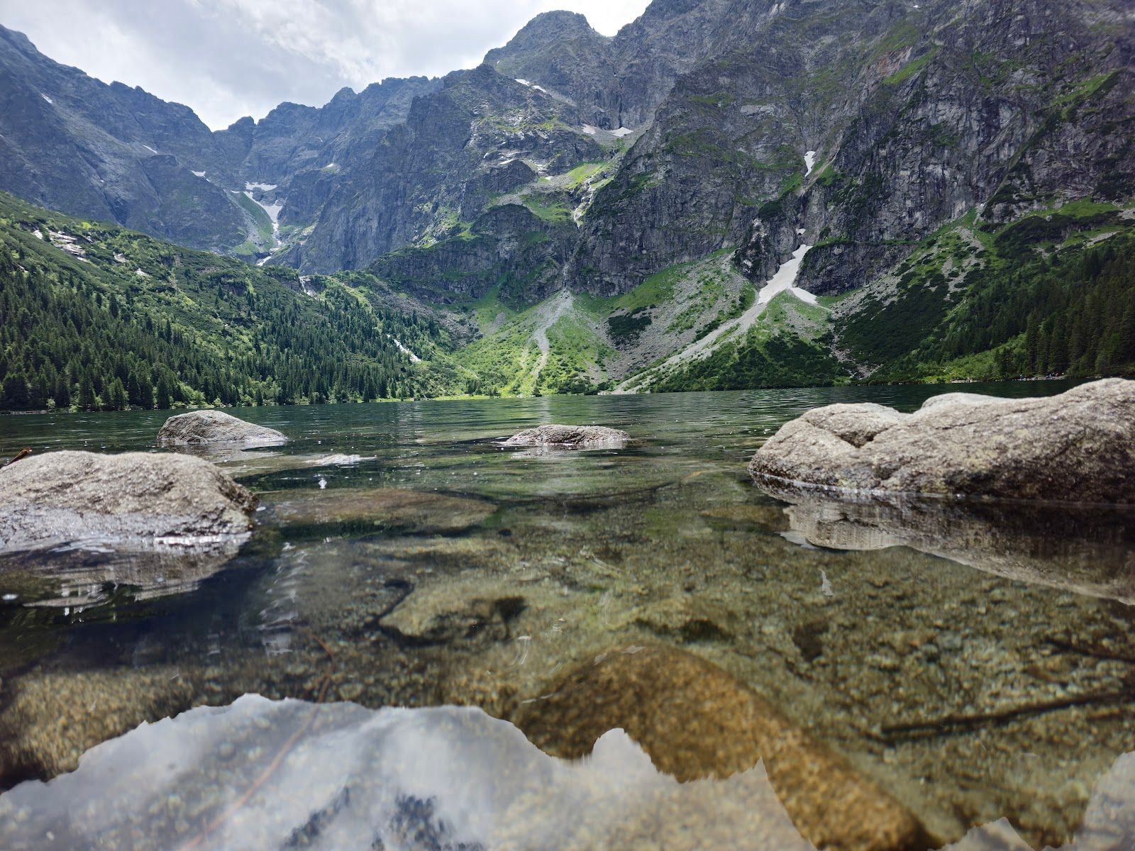
Morskie Oko
Morskie Oko is the largest lake in the Tatras: 34.5 hectares, 860 by 560 metres, with the water at 1,395 metres and a measured depth of 50.8 metres. The Tatra National Park trail from Palenica Białczańska is 11.60 kilometres of asphalt and stone, climbing about 7 percent, and the park marks it for wheelchairs and for beginners.
The lake the measurements closed
The Tatra National Park trail page calls Morskie Oko the largest lake in the Tatras. The sheet of water measures 860 by 560 metres and covers 34.5 hectares, at 1,395 metres above sea level. Older stories, the park writes, spoke of an underground link with the sea, specifically the Adriatic, and of shipwrecks and giant sea fish. Depth soundings begun in the 19th century and confirmed in 1934 set the maximum depth at 50.8 metres and ended those claims. The lake is poor in nutrients. The park says tourists have been feeding it nutrients anyway, by litter, by feeding fish, by soaking feet and by faecal pollution, so algae and plants are increasing. It is the only naturally stocked lake in the Polish Tatras. It used to be called Rybi Staw, Fish Lake. Beside the native brook trout there is brook trout from North America. The Rybi Potok flows out of the lake and names the valley. Mallards at the shore are there, the park says, because people feed them.
From the square in front of the PTTK hut the view is the valley of Rybi Potok. The wall opposite is the Mięguszowiecki peaks and Cubryna. Rysy and Niżne Rysy sit to the left and a little behind. The spire of Mnich is on the right. Nutcrackers around the hut are tame enough, the page says, to take food from a plate. Stone steps drop from the hut to the shore. If there is no snow, the circuit of the lake is about an hour and 2.5 kilometres. On that walk the park points to the rock walls, the big scree cones and the marks of rockfalls from recent years, waterfalls from the upper floors of the valley, and Swiss stone pines and spruces shaped by the climate.
The road that replaced the car
The walk starts at Palenica Białczańska, 990 metres. The path is the Road of Oswald Balzer, the highway from Zakopane through Jaszczurówka, Zazadnia and Łysa Polana to Morskie Oko, finished in 1902. Between the wars a Tatra car race was held on it. The stretch from Palenica to the lake was closed to road traffic in the 1980s after landslides damaged it in several places. In 1998 it was closed to bicycles because of collisions with people on foot. The surface now is asphalt and stone. Average gradient is 7 percent. The park’s walking times on the same page are printed twice and do not match: one pair is 4 hours up and 1 hour 30 minutes down, another is 4 hours 30 minutes up and 3 hours 30 minutes down. Use the page on the day, not a single remembered figure. The temperature at the lake is on average 5 degrees lower than at the start.
The first part follows the lower Białka valley, which the park calls the largest Tatra valley, over 60 square kilometres, cut by a Pleistocene glacier 14 kilometres long and over 300 metres thick. After 600 metres a bridge crosses a stream that joins the Białka. On that stretch the river is the border of Poland and Slovakia, of Podhale and Spiš, and of the two national parks. The name comes from the white stones in the bed. Carpathian alder grows on the banks. Across the water is Czerwona Skałka, and further on the U-shaped Slovak Biała Woda valley, with Gerlach, 2,655 metres, the highest Tatra summit, above it. The road then climbs the slopes of Wołoszyn through planted spruce damaged by the halny wind and by bark beetles. A stone bridge of 1900 looks onto Wodogrzmoty Mickiewicza, the waterfalls of the Roztoka where that side valley hangs above the Białka. The name was given in 1891, when Mickiewicz’s remains were brought from Paris to Wawel. Shortcuts between the road’s bends cut about a kilometre. Włosienica, a former pasture, is where that lower road ends. South of it the Mięguszowiecki walls close the valley. The road then crosses Żleb Żandarmerii, a gully of snow avalanches. The last large one, in February 2023, broke the trees whose trunks are still in the gully. The asphalt ends at a small square opposite the Old Hut, built in 1891 as a coach house and later adapted for beds. The present PTTK hut stands on the moraine bank. The first hut on that spot was already there in 1827. The current building is from 1908, in the Zakopane style.
FAQ
Can a wheelchair use the road, and how do I get to the start?
The park marks the Palenica–Morskie Oko route as available for wheelchairs and as suitable for beginners. The surface is asphalt and stone, 11.60 kilometres, with an average gradient of 7 percent. The page does not name a city-bus line from Kraków or Zakopane to Palenica. It does say you can drive, or use public transport from Zakopane and nearby towns, and that the drive from Zakopane is more than 20 kilometres. E-bus tickets are sold online and at the TPN information point at ul. Chałubińskiego 44 in Zakopane, open daily except holidays 7:30–16:30, not from the driver. Official parking is three zones. Staff fill Palenica first, then the road strip, then Łysa Polana, about 15–20 minutes on foot from the trailhead. You do not choose the zone. An online car ticket is quoted from PLN 36 to PLN 75 and is higher on the day. At the booth, if anything is left, the price is the top rate.
Is the lake inside the paid park, and are bicycles allowed?
Yes. Every Tatra National Park trail needs an entry ticket: PLN 11 normal, PLN 5.50 reduced, bought at a gate, online, or from the QR codes at entrances. Bicycles have been banned on the Palenica–Morskie Oko stretch since 1998. Cars have been banned since the 1980s. Horse carts still run from Palenica to Włosienica and stop there.
How long is the walk, and can I go round the shore?
The route page prints two pairs of times, 4 hours or 4 hours 30 minutes up, and 1 hour 30 minutes or 3 hours 30 minutes down. Check the live page. The shore circuit is separate: about an hour and 2.5 kilometres, and the park recommends it when there is no snow. The lake is 34.5 hectares, 1,395 metres up, and 50.8 metres at its deepest measured point.